Cantabria Places Map
Making it easier to find hikes and places to visit in Cantabria.
When I was travelling around South America, I used Maps.me a lot to find hikes as it was easy to look at the map and spot the hiking routes. When I moved to Cantabria I expected much the same, but there are so many paths here that it's surprisingly difficult to tell which ones are actual hiking routes. I was constantly searching blogs, tourist information websites and leaflets, trying to work out where a hike started and which trails were worth doing.
I started wondering whether I could build my own map, but collecting all that information was clearly going to take some time. Then we bought the Pasaporte Cultura, an annual pass covering 21 cultural attractions across Cantabria, including prehistoric caves, museums and historic sites. It seemed like a good way to explore more of the region, but every time we wanted to use it I found myself looking up the places individually to see where they were and whether we could visit a couple on the same day.
That gave me a much smaller problem to start with. I could research the passport places, get them onto a map and have something useful for planning days out, then start adding hikes as I found them.
Product screens and details
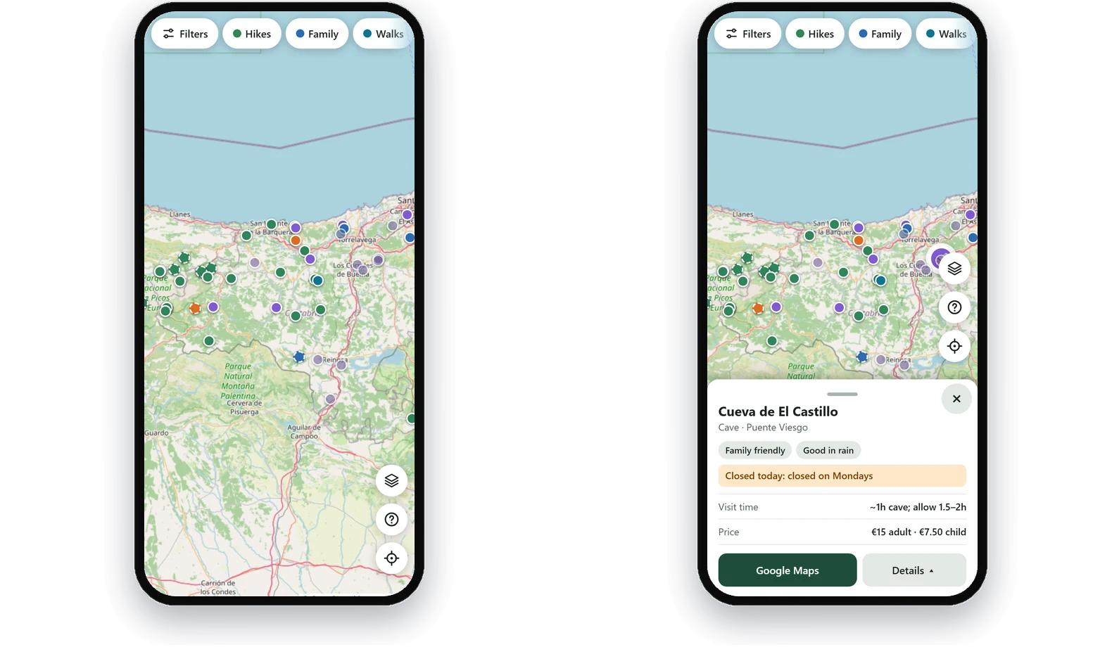


Explore the map
Pins for hikes, walks, family activities and Pasaporte Cultura sites. Open a place for opening times, prices and a link to Google Maps.
Hiking routes
A hike with a route is drawn on the map, with its distance and duration and the details of the route.
Filters and key
Filters for hiking stage, rainy-day options and opening days, and a key that explains every symbol.
Select a screen to enlarge it.
The story behind the project
The product
Explore Cantabria is an interactive map of places to visit and hiking routes around Cantabria and the Picos de Europa. It started with the Pasaporte Cultura attractions, but I've since begun adding hiking routes and other places I've discovered while exploring the region.
Rather than having to look up each attraction individually, I can see where everything is, what's nearby and which places could be combined into a day out. Each location includes useful information such as opening times, websites and links to Google Maps. The hiking layer is gradually being expanded with actual routes drawn on the map, rather than just pins showing roughly where a hike is located.
I designed it mainly for use on my phone, with filters for different types of places and activities and a saved version for when there's no connection. It's still a work in progress, particularly the hiking routes, but it already makes planning days out much easier.
Building it with AI
The project actually started while I was out hiking. I'd been thinking about building my own hiking map for some time, and we'd recently bought the Pasaporte Cultura. I was struggling to work out where all the attractions were and which ones we could visit together, so while we were walking I asked ChatGPT to research the full list for me.
We went through the places, finding official websites, opening times, locations, distances and other useful information. We put all that research into Notion. By the time we'd finished, I had a fairly comprehensive collection of information, but it was still a list. That's when I decided to turn it into a map.
I used AI to help build the first version with Leaflet and OpenStreetMap, using the information we'd collected in Notion. A build script now turns snapshots of that data into the files the site uses, so I didn't need to build a separate database or admin system.
Once the passport map was working, I returned to the original idea of mapping hiking routes. This has been considerably more complicated. There are plenty of paths marked on maps, but identifying actual hikes, finding reliable route information and knowing where to start isn't always straightforward. I've been researching routes through official tourism websites, published walking guides, Naturea Cantabria and OpenStreetMap. I decided not to show a hike unless I had a usable route for it, rather than just dropping a pin somewhere on a mountain. I also distinguish between verified and approximate locations instead of inventing coordinates. There are already some hiking routes on the map, but plenty more I still need to research.
The mobile interface has needed several rounds of improvements too. The early version didn't fit smaller screens particularly well, and I hadn't included a key to explain the different symbols. I used AI reviews to identify issues and worked through changes to the filters, accessibility and how the place information was displayed.
One unexpected problem came when the website worked on my laptop but wouldn't load on my phone at weekends. After investigating, I found that Spanish ISPs were blocking Cloudflare IP addresses during LaLiga football matches, and the addresses used by my site were affected. Since weekends were exactly when I was most likely to use the map, that was a problem. I already had Hostinger hosting, so I moved the website there and kept Cloudflare for DNS. I've also improved the caching and offline behaviour after finding that my phone sometimes displayed an older version of the site.
Results and reflections
The map is live, and I've already got something useful out of the original research. What began as a list of cultural attractions has become a website I can use to plan days out, and I've started adding the hiking routes I originally wanted.
There's still a considerable amount to do. The Pasaporte Cultura gave me a manageable first project, but researching and mapping hiking routes across Cantabria is much more involved. I'm gradually adding them as I find reliable information.
What I like about this project is that it started with a conversation while I was out walking. I used ChatGPT to carry out the research, organised the results in Notion and then used AI-assisted development to turn that information into a working website. The research was useful on its own, but turning it into a map made it much easier to use.
Continue exploring


Have an idea or a process you want working?
I take ideas from spec to a working product, and the same approach applies to automation and AI projects inside organisations.